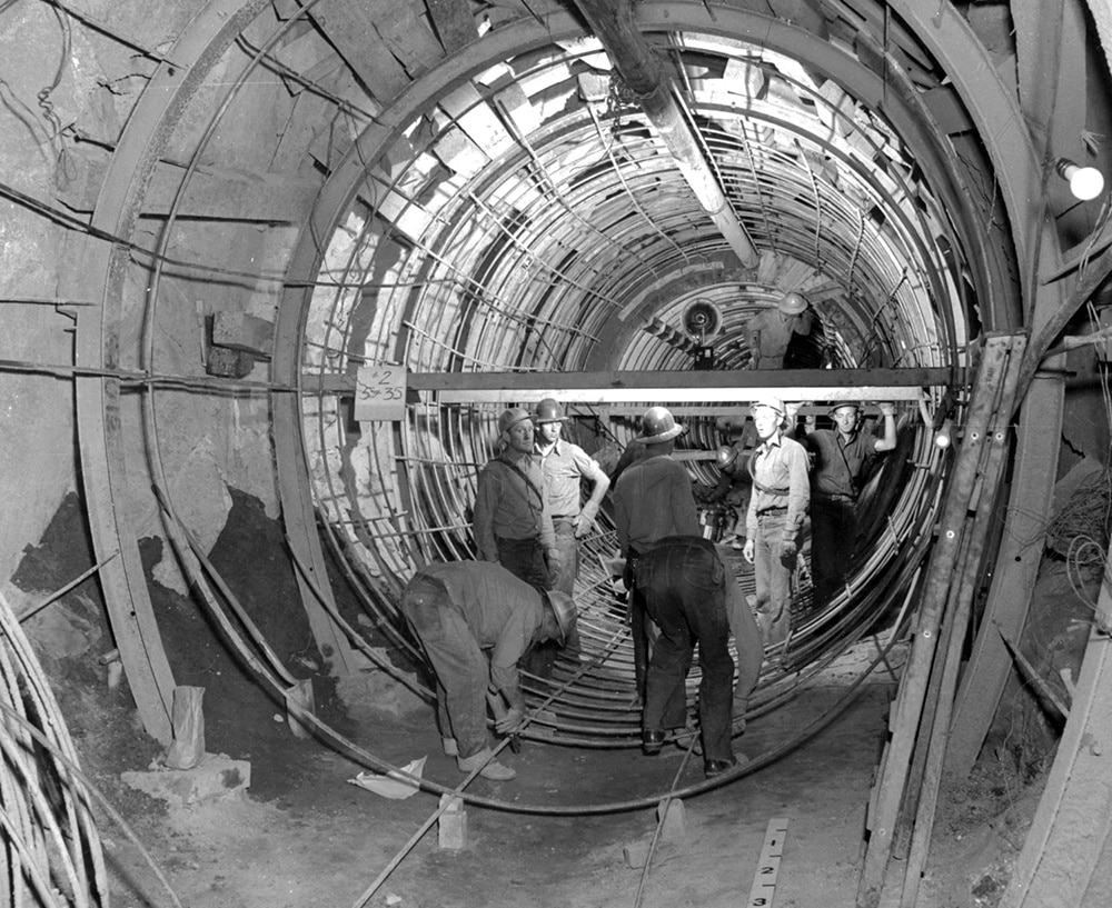
Construction of the Mono Craters Tunnel in the 1930s. Photo courtesy of the Los Angeles Department of Water & Power.
Groundwater Exports Benefit Los Angeles, Impact Mono Lake
by Geoff McQuilkin, Executive Director, Mono Lake Committee
This article was first published in the Winter & Spring 2022 Mono Lake Newsletter.
DWP captures more than streams in the Mono Basin
Heading south from Mono Lake, drivers on Highway 395 zoom past a road junction marked with a sign for a mysterious “West Portal.” Portal to what? Is there a matching one in the east? Is this a science fiction destination, perhaps a portal to another dimension?
Follow the dirt road in search of the portal and you’ll find sagebrush and a century of history involving—like so many things in the Mono Basin—hubris, the Los Angeles Department of Water & Power (DWP), and the Los Angeles Aqueduct. Not to mention that the portal itself leads into a hidden water source that flows free of oversight to the distant city at around 375,000 gallons per hour.
Last century’s engineering achievement
West Portal was a DWP company town, constructed in 1934 just west of the looming ash grey, thousand-foot slopes of the Mono Craters. Paved roads served 26 buildings that featured conveniences including electricity and water service. More than 200 workers lived in barracks and ate in dining halls; on a day off they sometimes went to Lee Vining for activities including recreation at the local dance hall, which is now home to the Mono Lake Committee. West Portal hummed with activity during its seven-year existence as workers labored in shifts around the clock.
The location of West Portal was determined solely by the engineering calculations that fueled a massive plan to extend the Los Angeles Aqueduct into the Mono Basin. The goal? In the straightforward words of DWP engineer H.L. Jacques: “The Mono Basin Project is being constructed in order to increase the water supply of the city of Los Angeles.”
The town and the portal itself were built to tackle a daunting engineering challenge: Mono Lake lies at the center of a closed watershed. Its tributaries naturally flow downhill to enter the lake and no water flows out. To divert the streams with dams and then move that vast quantity of water to the city, DWP would have to blast a path out of the Mono Basin.
Jacques summarized the challenge dryly: “The main feature of the project is the construction of the Mono Craters Tunnel, 59,812 ft. in length, through the mass separating the Mono Basin and the Owens River watershed.”
The mass he refers to, it turns out, is the indeed-massive Mono Craters chain of quite recently-erupted rhyolitic plug-dome volcanoes. The tallest peak reaches above 9,000 feet in elevation and winter snow blankets the young mountain range that stretches ten miles south from the edge of Mono Lake.
DWP crews set records for their pace of drilling and worked from a remarkable six different headings: the West and East portals, plus drilling outward from the bottom of two separate vertical shafts sunk hundreds of feet into the craters.
Boring through volcanoes is no easy task. They encountered rhyolite tuff, volcanic ash, basalt, and glacial gravels while drilling; some materials immediately slumped into the tunnel and extensive bracing and concrete lining operations were required. Faults and fractures were encountered, plus vast quantities of carbon dioxide that required building extensive ventilation systems and, ultimately, sinking a third 535-foot vertical shaft just for fresh air. But perhaps the biggest challenge was the water that gushed into the tunnel in tremendous volumes, posing a major construction obstacle but becoming, ultimately, a major benefit for DWP.
The tunnel, which is more than nine feet in diameter, was completed in 1939. Stream diversions into the Aqueduct wouldn’t begin for another two years, but the tunnel immediately produced a steady flow of water for Los Angeles.
A water source of its own
As a town, West Portal didn’t last a decade, but its purpose was met: the Aqueduct and the portal into the Mono Craters Tunnel persist today. Standing at the former town site, you can hear water rushing by on days when surface water export operations are underway, the cool flow of Rush and Lee Vining creeks slipping south and away from Mono Lake.
But today State Water Resources Control Board rules limit stream diversions, and there are plenty of days when the West Portal is dry and the only sound is the wind. It is not so eleven tunnel miles away, on the other side of the craters.
At the East Portal there is never a dry day. Water flows out of the tunnel and off toward Los Angeles at every hour, averaging about nine million gallons every day, annually rivaling the flow of Parker Creek, one of Mono Lake’s tributaries.
“The water originates as snow and rain falling on and around the Mono Craters, which then moves rapidly down through the very pervious pumice into the sub-surface jumbled geology and becomes part of the groundwater systems of the Mono Basin and the Upper Owens River Basin,” says Peter Vorster, expert Mono Basin hydrologist and longtime Mono Lake Committee advisor. “Over the last 30 years the tunnel has captured on average about 10,000 acre-feet of that groundwater per year and it is estimated that 50% to 60% of it would otherwise have flowed toward Mono Lake.”
In effect, the tunnel is a drain drilled deep beneath the Mono Craters that captures groundwater for the Aqueduct, adding it to the surface water currently diverted from Mono Lake’s Sierra tributaries and bumping up the total volume of water flowing out of East Portal by 60%.
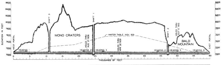
A 1939 profile of the Mono Craters Tunnel, illustrating its 11-mile route beneath the Mono Craters and the groundwater table (dashed line). DWP engineers expected to capture substantial amounts of groundwater with the tunnel; today the tunnel delivers about 10,000 acre-feet of Mono and Owens water annually to the Los Angeles Aqueduct system. Graphic from “Mono Craters Tunnel Construction Problems” by H.L. Jacques.
Part of the plan
Few are aware of this Mono Basin groundwater supply today, beyond a small group of Mono Basin and Committee experts. It was no surprise, however, to the engineers who planned the tunnel. In fact, groundwater was expected to be a substantial water benefit. It was also one of the biggest tunnel construction challenges.
Tunnel workers hit water within a mile of West Portal and by the time they were four miles in, a stream-like 20 cubic feet per second (cfs) of water had to be continually pumped out through a network of pipes to keep the tunnel dry enough for drilling operations to continue. “The dewatering of the tunnel has been a serious problem during most of the operations,” reported a DWP engineer.
The tunnel engineers also knew that, when complete, the tunnel would capture—or “make”—enough water to be a major benefit to the LA Aqueduct and city. In 1939 Jacques wrote that “it is expected that the waters of Rush Creek … plus some 30 [cfs] made in the tunnel itself, will be delivered into the Owens River early next year.”
DWP hydrologists noted the continuing groundwater capture in a 1984 report, writing “The inflowing groundwater (tunnel make) averages 12,000 [acre-feet per year]… About half the tunnel length underlies the Mono Basin watershed and the remainder underlies the Long Valley Basin watershed. It is assumed that half the tunnel make is water that would otherwise be tributary to Mono Lake.”
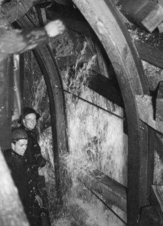
Water streams into the Mono Craters Tunnel in this 1939 photo. Groundwater was a major challenge during tunnel construction—and has been a major benefit to DWP since the tunnel was completed. Photo courtesy of the Los Angeles Herald Examiner photo collections/Los Angeles Public Library.
Many decades, lots of water
Last year, DWP diverted 16,000 acre-feet of water out of Rush and Lee Vining creeks and sent it off through the Mono Craters Tunnel for delivery to Los Angeles. But more than 25,000 acre-feet came out the other end of the tunnel.
By volume, that’s enough water to submerge every corner of the sprawling city of Los Angeles with an inch of water. Here at home, that same volume of water would raise Mono Lake more than half a foot.
The tunnel has been in operation for 83 years, and its groundwater capture alone adds up to large volumes of water.
The tunnel has captured about 90,000 acre-feet of Mono and Owens groundwater for Los Angeles in the past decade and over 260,000 acre-feet since the 1994 State Water Board decision required DWP to raise Mono Lake to a still-elusive healthy level.
Incredibly, the tunnel has captured nearly one million acre-feet since construction. That’s enough water to supply every resident and business in modern Los Angeles—for two years!
Equally incredible: the tunnel has deprived Mono Lake of around 525,000 acre-feet of groundwater inflow since it was built. Coincidentally that volume of water, if it was somehow instantly returned, would jump Mono Lake’s level from today’s troublesome low all the way up to its required healthy management elevation.
The Mono Lake connection
Snowmelt in the Sierra that flows down the tributary streams is the largest and most visible contributor of water to Mono Lake each year. But large quantities of water move underground as well, and groundwater is an important element of the overall water balance in the Mono Basin, adding up to about 12% of the annual input to the lake.
DWP’s diversion of Rush and Lee Vining creeks reduces surface water entering the lake while the Mono Craters Tunnel reduces the groundwater inflow. The significant impacts of surface water diversions on fish, wildlife, and stream habitats are well documented, with restoration work underway. The impacts of groundwater export are less known, but springs, seeps, and habitats dependent on the slow underground flow of groundwater toward Mono Lake have been altered since the tunnel’s construction.
Quantification of Mono Basin water is essential to understanding the impacts of water exports on Mono Lake and projecting future lake levels. Averaged over 30 years, the tunnel has captured a total of about 10,000 acre-feet of water annually for the Los Angeles Aqueduct. Of that, around 4,500 acre-feet entered the tunnel as it runs through the adjacent Upper Owens River watershed, where nearby springs have dried out as a result.
That means 5,500 acre-feet of groundwater on average has departed the Mono Basin as an annual water export, rather than flow to Mono Lake. The tunnel’s groundwater export is an important part of understanding and projecting the level of Mono Lake, and it is accounted for in the hydrologic model of the Mono Basin constructed by Vorster and the Committee team.
Water, without regulation
The groundwater captured by the Mono Craters Tunnel provides millions of dollars of value to DWP annually. Yet from a regulatory perspective the water in the tunnel has flowed off the books.
DWP fills its Aqueduct by capturing Eastern Sierra water sources that are subject to a patchwork of regulatory authorities. At Mono Lake, diversions from tributary streams are regulated by the State Water Board, the source of the landmark 1994 Mono Lake protection decision. In the Owens Valley, water rights for surface diversions are constrained by court review and state regulations, and extensive groundwater pumping operations are regulated by groundwater agreements with Inyo County.
But no regulatory authority currently monitors the groundwater collected by the Mono Craters Tunnel, nor is it subject to any legal agreements. No agency or court requires reporting on groundwater capture, oversees its volume, nor mandates mitigation of its impacts. In fact, it appears that the Mono Craters Tunnel is the largest unregulated, unreported, and unmitigated source of water entering the Los Angeles Aqueduct.
Permanent Mono Basin water for LA
A highway sign, dirt road, and a few foundations in the sagebrush are all that remain of the town of West Portal. But the work of those DWP laborers and engineers persists.
The Mono Craters Tunnel connected watersheds and changed the hydrology of Mono Lake and the Mono Basin. The tunnel and the Aqueduct made the Mono Basin part of the Los Angeles watershed, and the future of Mono Lake is bound to the future of water management in LA.
With Mono Lake still lingering at an unhealthy low level, the State Water Board plans to consider changes to the rules that govern DWP’s stream diversions. Cutbacks may be made to ensure Mono Lake rises. Regardless, Mono Basin groundwater will continue to trickle and cascade into the Mono Craters Tunnel on into the future, providing water of great volume and great value to Los Angeles.
Call to Action
Like the Mono Craters Tunnel, irrigation in Long Valley remains at the mercy of DWP. Water issues throughout the Eastern Sierra are interconnected not only through the environment, culture, and local economy which relies on this critical resource, but also through the extractive changes made by the city of Los Angeles. It will take pressure from customers, the citizens of Los Angeles, for DWP to consider changing their management practices in the Eastern Sierra. Please share this newsletter and the websites of The Mono Lake Committeeand Keep Long Valley Greenwith your circles, especially those who are residents of Los Angeles, so that we can continue to fight for every last drop in Payahuunadü, the land of flowing water.
Why do YOU want to Keep Long Valley Green?
Let us know by writing to us at [email protected], or messaging us on our social media platforms: Instagram and Facebook @keeplongvalleygreen, and Twitter @LongValleyGreen.